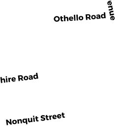
14 AYRSHIRE RD
Owner Information
NOONAN,ANDREW
14 AYRSHIRE RD
WORCESTER, MA 01604


Property Details
14 AYRSHIRE RD is classified as a Single Family Residential (Ranch).
The primary structure on this property was built in 1950. There are 2368ft2 of built area within this property. There is 1100ft2 of residential/living space within this property. This property is listed as having 5 rooms.
14 AYRSHIRE RD is valued at 227300. The land is valued at 66100 and the structures are valued at 159300. There is an additional valuation of 1900 on this property.
This property is in Zone RL-7. Confirm with local Zoning Board authorities to ensure there are no overlays or other easements on this property.
The most recent deed for 14 AYRSHIRE RD is recorded at the local registrar in Book 56379, Page 0311. 14 AYRSHIRE RD was last sold on 2016-11-29 for 192500.
Assessment data from fiscal year 2021.
Flood Data
According to the FEMA National Flood Hazard Layer, this property does not appear to be in a flood zone. It may also be in an area not yet reviewed. Nonetheless, confirm this information prior to taking any action.
To view the flood hazards around this property, create a FEMA "Firmette" Map of the area around 14 AYRSHIRE RD.
Broadband Internet Providers
| Provider | Type | Bandwidth (mbps) | |
|---|---|---|---|
| GCI Communication Corp. | Satellite | 0 | 0 |
| Viasat Inc | Satellite | 100 | 3 |
| Crown Castle Fiber | Fiber | 0 | 0 |
| Verizon New England Inc. | DSL | 5 | 0 |
| T-Mobile | Fixed Wireless | 25 | 3 |
| VSAT Systems, LLC. | Satellite | 2 | 1 |
| Charter Communications Inc | Cable | 940 | 35 |
| HughesNet | Satellite | 25 | 3 |
Broadband service provider data from December 2020.
Adjacent Properties
- 24 NONQUIT ST
Single Family Residential owned by HOWELL,CARL W + NICOLE B - 22 AYRSHIRE RD
Single Family Residential owned by LANTINEN,JILL E - 12 AYRSHIRE RD
Single Family Residential owned by AYALA,DANIEL + AMARIS I - 28 NONQUIT ST
Two-Family Residential owned by SCAMPINI,JOSEPH J TRUSTEE - 26 NONQUIT ST
Single Family Residential owned by SHAW,AMANDA H